
 joseph.leach
ca0a0461a8
joseph.leach
ca0a0461a8
|
4 years ago | |
|---|---|---|
| img | 5 years ago | |
| .gitignore | 5 years ago | |
| LICENSE | 5 years ago | |
| Pipfile | 5 years ago | |
| Pipfile.lock | 5 years ago | |
| README.md | 4 years ago | |
| audit_charging_stations.json | 4 years ago | |
| charging-stations-improved-version.py | 4 years ago | |
| charging-stations.py | 5 years ago | |
| preview-audit.json | 4 years ago | |
| preview-improved-version.json | 4 years ago | |
| preview.json | 5 years ago | |
| requirements.txt | 5 years ago | |
| results-audited-readable.osm | 4 years ago | |
| results-audited.geojson | 4 years ago | |
| results-audited.osm | 4 years ago | |
| results-improved-version.osm | 4 years ago | |
| results.osm | 5 years ago | |
README.md
london charging stations
at fosdem 2019 talks on linking wikidata and osm and using thousands of taxi gps traces to improve osm gave rise to an idea to consider osm as a platform for syndicating government open data, the next step was to try and find a way to semi-automate bulk imports of open data with osm community backing
the gis team at london city hall are working to establish a re-usable means of releasing open data to osm, licensed via the open government licence and compatible with the open database licence
initial investigations
there were some initial queries to the talk-gb-london group and the author of osm.wikidata.link, a visit to the london meetup and a visit from the community interest company - the initial support from osm has been exemplary
assistance to osm
we provided geocoded ofgem environmental performance certificate data of 1314 photo voltaic installations in london
first try with id and maps.me
to learn more about osm, we had a go at using iD, the osm in-browser editor and a maps.me note to map a series of 18 newly installed drinking fountains individually, and received some guidance on the use of tags in changesets
current osm data on charging stations
https://overpass-turbo.eu/s/HKc
details of how to maintain tags on charging stations
https://wiki.openstreetmap.org/wiki/Tag:amenity=charging_station
gla held record
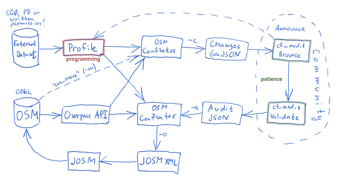
using osm conflate
installing dependencies and running charging-stations.py
dependencies - osm_conflate for running checks against osm, and requests for getting gla data from geoserver - are managed with Pipenv but could be done with pip and requirements.txt, which may be more portable to some environments
pipenv install
pipenv shell
conflate --changes preview.json --output results.osm charging-stations.py
after the audit has completed, you run charging-stations.py again with the -a audit_charging_stations.json parameter include the changes from validation
conflate --changes preview-audit.json --output results-audited.osm -a audit_charging_stations.json charging-stations.py
...or
pipenv install
pipenv run conflate --changes preview.json --output results.osm charging-stations.py
note on the flags used above
conflate --help
-c CHANGES, --changes CHANGES
                        Write changes as GeoJSON for visualization
-o OUTPUT, --output OUTPUT
                        Output OSM XML file name
main details on installation and use
https://wiki.openstreetmap.org/wiki/OSM_Conflator
workflow to semi automate data release
the community part of the workflow is implemented in an additional project osm-conflate-audit
example profile.py scripts in git repo
https://github.com/mapsme/osm_conflate/tree/master/profiles
unfinished locations
some charging stations in this dataset are not actually installed yet, and are listed without coordinates, these are filtered out in the profile
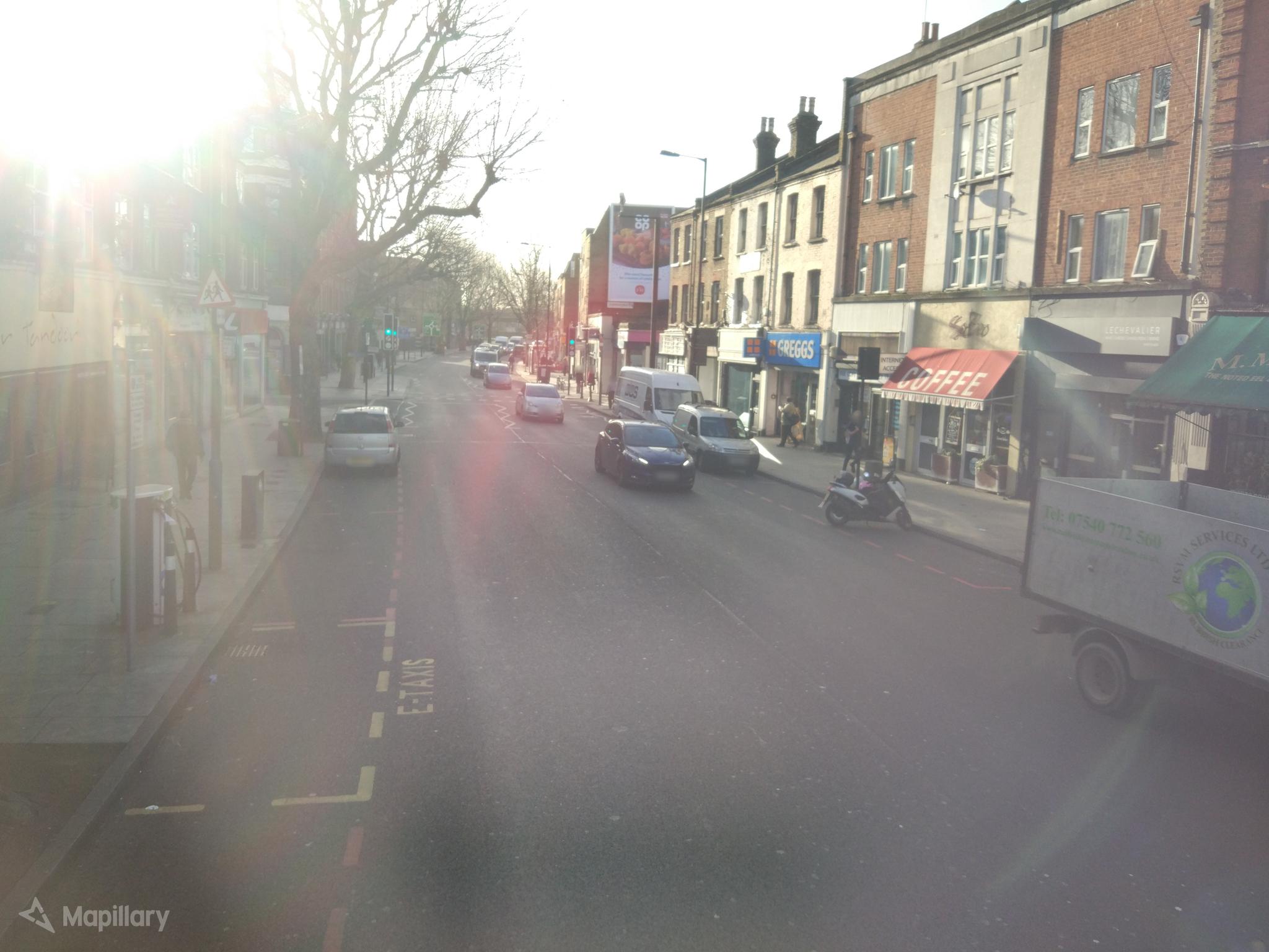
mapping charging stations restricted to taxis
here's a photo of a taxi-only charging station on tower bridge road:
we received some guidance on talk-gb-london on how to achieve this:
For the stations that are restricted to taxis... would it be appropriate to use the access=* tag? It is mainly used for roads/paths and gates etc, but I think it is used in other cases to specify "who is allowed to use this feature".
The wiki page for access suggests that the way to do it would be the combination of
access=privateandtaxi=yes